We found our first cache in the rain in Eureka! OK, Mike and Larry found our first cache in the mist in Eureka. Cynthia and I stayed in the car to provide them instructions in case they looked in the wrong place. Still no views of the ocean! But, there is always Crescent City!
 We saw the ocean. It was still gray and not very pretty, but we saw it. We were somewhere north of McKinleyville! We could only look! Fortunately, we knew we could actually get out of the car when we reached our next cache. Oops, we missed the exit! The next exit didn’t get us to the cache so we used it to make a”U-turn” and headed south again. Ooops, no exit from this side. Another U-turn and we took the correct exit! Sometimes old topo maps just don’t give the correct story! When we finally arrived we actually got to get out of the car and really look at the ocean!
Brrrrrrrrrr! It’s cold out there! We were at Houda Point and we had a good view of Little River Rock. Too bad the sun was not shining. That didn’t stop us, though. We found the cache, enjoyed the ocean, took pictures, and headed on our way. Brrrrrrrrrr!!! It’s cold out there!
After experiencing the cold, we had to make a pit stop. We stopped at the gas station in Trinidad (California, that is). To his surprise, Larry found a Big Hunk candy bar. He had not had one since he was a kid so he bought one as a special treat. Once in the car, we all remembered our childhood experiences with Big Hunks. Larry, Cynthia, and Mike all loved Big Hunks as kids. I didn’t then and I still don’t like them now. They debated whether they tasted best when fresh or when eaten directly from the refrigerator or freezer. It seems that when taken from the refrigerator/freezer and dropped on the floor, they would break into little pieces (still in the package) and were really good to eat. As I said, I didn’t like them then and I still don’t!
The closer we got to Crescent City, the foggier it got. We had a little trouble with tracking our route as the GPSr didn’t like the weather conditions. That and the trees along the highway presented problems. I jokingly accused Mike of leaving the road. He agreed that it was hard to even find the road with the foggy conditions. Just as suddenly as we were in the fog, we were out of it, and back in it again.
Somewhere along the way we passed the Mystery Trees resort area. There in front, bigger than life, were Paul Bunyon and Babe, the blue ox. There is history with Paul Bunyon and Babe. Cynthia and I are sisters and our father used to regale us with stories about his adventures with Paul Bunyon. In fact, he helped Paul and Babe dig Puget Sound in Washington. My son, who lived outside of Seattle for a time, tried to tell me that the people of Seattle are unaware that Paul had anything to do with creating Puget Sound. I prefer to think that those people were unfamiliar with their history! Cynthia and I tried to convince Mike to stop the car just so we could get a picture. Sorry--we were on a mission so we could not stop. Maybe next time.
 Once we got to Crescent City, we headed to the ocean to check out two monuments. One was dedicated to an historical light house--Saint George Reef Lighthouse. The other was “dedicated to those who lost their lives in the wreck of the Pacific Mail Steamer ‘Brother Johathan’ at Point St. George’s Reef July 30, 1865”. Still overcast, but we took some pictures of the coast line and the monuments.
After leaving Crescent City, we were driving through more forest areas. We tried to take a picture to show the magnificent trees, but they all were just a blur as the car was moving. You will have to take our word for it, or make the drive yourself and enjoy the scenery. The river was also beautiful, as were the rhododendrons interspersed in the forest. It really was a beautiful area. Quite a contrast from our journeys through Nevada. At one point we did stop and Larry and Mike climbed over the wall to get just the right angle on the river below. We also stopped for a cache and while Mike & Larry found the cache, I snapped a few pictures of the river.
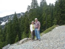
 Hooray! We took a wrong turn to get to a cache and ended up on the opposite side of the river at an old vista point. We had to get out to check the river and identify a better access route to the cache. A photo OP! Couldn’t resist it! We needed some green pictures to counter balance our brown collection taken in Nevada.
 We finished the counties and quads we wanted to get in the north western part of California. Time to head east. The easiest way to do that is head north to Grants Pass, Oregon, across to Klamath Falls, OR and down 39/139 to California and Modoc County. I told you we were on a mission and we were! On our journey across country, we passed by the Upper Klamath Lake and admired it from the car. At one point we thought we were passing right through it and we might have to drive on water--it was that close to the road.
Once back in California, we passed through the Tulelake area on our way to Modoc County. This is the first time Larry and I have ever been in this area. It is an area rich in history. (Not necessarily good history, but history none the less). As it turned out, the cache we were seeking was along the fence line that identifies the internment camp boundaries. It was very near a monument “Placed by the State Department of Parks and Recreation in cooperation with the Northern California-Western Nevada District Council, Japanese American citizens League, May 27, 1979”. I know that the internment would not be an appropriate action today, but my parents were terrified when Japan attacked the United States. My Mother’s family lived on Oahu and my Grandfather was a civilian employee at Pearl Harbor. It was a whole different world back then.
 We headed for one more cache in this immediate area before heading back to Weed, CA. Believe it or not, it was actually out a dirt road and required that we climb some rocks. OK, so we could have walked around the rocks like Mike did, but it was more fun to climb up the rocks following Larry. And, we finally remembered to take a picture looking back at our vehicle from the cache site--shades of our Nevada excursions only we didn’t have our jeeps on this trip!
 Now, back up 39, across 161 and down 97 to Weed. Yes, we picked up a couple of caches along the way, but only enough to satisfy our needs for a couple of quads (geocachers will understand). One of the caches was a memorial sculpture garden so we enjoyed getting out of the car and going for a little walk.
By the time we arrived in Weed, we had been in the car almost 12 hours. We went from the rain to the sunshine, from the coast to the interior, from the redwoods to the pines, from California to Oregon and back again, and, from sanity to craziness! It definitely was a whirlwind trip! But what a blast!

No comments:
Post a Comment