We have spend a lot of time on the top of Tufa mounds and today was no exception. We started the day with breakfast at Bruno’s and then drove to our first cache of the day: an ammo can hidden in a crevice at the top of a Tufa “mountain”.
 Mike and I climbed to the top. Well, Mike climbed to the top and I climbed to just below the top. Mike actually retrieved the cache, but I could see it (once he held it up). Larry was taking pictures from below and Cynthia was monitoring our safety! It certainly was a team effort.
We took various and sundry roads (mostly dirt roads) headed south and then west; ultimately ending up in California. We did have to make a slight detour. We followed one main dirt road that was supposed to take us to Hurlong. We got all the way to the locked gate. The town was on the other side, but the gate was locked and we didn’t have the key. Someone thought they were cute and had left a sign on the gate identifying the other side as a “gated community”. I guess they wanted to keep the riff-raff like us out! So, back we went and found a main road over to 395 and headed north.
We had not gone far before we were stopped by road construction! We sat for a while before it was our turn to go. We eventually arrived at our destination, no thanks to the locked gate and Caltrans . We also gave ourselves a good “talking to” because we forgot to take a picture of the sign at the gate.
 Once in California, we headed for Plumas National Forest . We picked up a few caches, but there were two that were noteworthy. The first one was the Otis Overlook Cache (GCGR3D). The elevation of the cache was 6400 and we had a beautiful view of Honey Lake Valley.
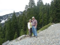
  At this cache we were in Plumas National Forest and, more specifically, in the Diamond Mountain Range. To and from the cache we passed meadows, wetlands, and several large ponds. We got some great pictures at the top. The views were incredible. We almost felt like we were back in Nevada as we were still rock climbing to get the cache.
 The other cache was the “Meadow View Cache” (GCJPC5). According to the information about the cache, it is “Located near the 6000 foot level in rocky and somewhat steep terrain. A 4x4 vehicle with at least 12” of ground clearance and a good driver with moderate experience is mandatory.” We followed the owners instructions and located the access road. We looked at the “road” and looked again. It had not been used in some time! I think Cynthia referred to it as “a road less traveled”!
 We followed our fearless leaders (Mike & Cynthia in GeoJeep) up what little of the road was still visible. I guess both our drivers (Mike & Larry) had what it takes to navigate this “road” and get us to the cache.
  When we reached the a point where we thought we were at the end, we still had a couple of hundred feet to walk--up hill. We made it! We found the cache and took more pictures. We took even more pictures on the way back as we now knew where most of the “fun” spots were. We can safely say that where once a road was, there is one again.
We actually ended this adventure back in Reno. After one last cache on the way out of Reno, we parted company. Cynthia and Mike (Geo-Jeeper) headed home in GeoJeep, while we headed for home in our Golden Retriever. We had a lot of fun, but we were ready to sit in our comfortable reclining chairs and to start enhancing our memories!