 I can’t believe it, we actually left Cynthia & Mike’s house before our projected departure time of 7:00 AM. True, it was only by 20 minutes, but 20 minutes is 20 minutes. Besides, we had to make our traditional stop at Starbucks. By the time we had our coffee in hand, it was still before 7 and we were on our way to Tahoe. We headed out via the Mt. Rose Highway. Up, Up, Up we went. Round, round, round we went! It was a “steep” climb from roughly 4100 ft. to 8260 where we stopped for our first cache at the Mt. Rose Ski Resort. We actually got to 8889 before we crossed over the “Highest Year Round Sierra Pass” and headed down into the Tahoe area.
 One of our first caches we found was just off the Cave Rock Trailhead, The walk to the cache was pleasant enough, but then we had to suspend ourselves on the side of a hill. Mike and I headed down hill, first to the trees and then to some rocks. We were “climbing” all over that tree as we were sure it was there somehwere. I eventually found the cache a little further down the trail. It was a fake rock next to a larger rock under a bush. I was precariously balanced while I signed the log with our geocaching names. There are lots of pictures of that one!
 We spent a little time in a wooded location along a fire trail and found the cache decorated with the pieces of a pine cone. After finding the cache, we walked to a nearby park and watched a few minutes of a baseball game in progress. One ended and another started while we watched. We were taking a rest.
After that we headed to a nearby cemetery. It was an old cemetery and one of the neighbors came over to ask if we knew anyone residing in the cemetery. We told him no, that we just had an interest in old cemeteries. I took some pictures and we chatted a while to distract from what the others were doing. We had quite a lengthy discussion about cemeteries, genealogy, and the important Tahoe families that were buried here. Eventually, he got tired and returned to his house. Then we could get down to business and find the cache! He was a talkative sort!
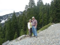
 At one point, we were on the edge of a fabulous meadow. It really was beautiful. Cynthia and I posed for Larry to take our picture while Mike grabbed the cache and signed the log. The neighbors were right there in their backyard so we had to be stealthy! We got a good picture out of the deal and all their attention was focused on us.
 A little further along on Hwy 89, we came to the Promanade Walk. The Old Tallac Hotel used to be the site of a major resort at Lake Tahoe. There is an old walkway that connected this hotel with the Tallac Point House. The walkway was called the Promanade. The guests could walk between the two at night along this lighted path. We met another geocaching family (hawaiilovers) at the start of the path. We all walked along the path together. It was one of the sons who made the find. Nice family. This was such a nice walkway. We could imagine how much the guests enjoyed it in it’s day. Too bad they had to take down the resort. I guess the daughter was concerned about the impact on the environment even back then.
 We stopped for lunch at a location familiar to Larry & Me--The parking lot by the Vikingsholm Trailhead. We have hiked the Rubicon Trail along the west side of the lake from this point to DL Bliss State Park so we were familiar with the area. We had a fantastic view of Emerald Bay from this location.. We set up a tailgate party in the parking lot as it was a little breezy to be eating from a point where we had a view. This way we could enjoy our sandwiches while we watched the other cars jockeying for a parking spot. I’m sure they were wising we would hurry up and eat.
 Along our route we found several Mile Marker caches. A geocacher named “AppleJohn” has been working on placing a geocache near every mile marker around Lake Tahoe. He has now placed a cache near every marker but three along the westside of the Lake from South Tahoe to North Shore. We found some of them in interesting locations. They were not always right at the marker. Sometimes we had to follow trails off the road a bit and one of them was a multi which meant we had to find a couple of stages before we found the final location of the cache. At one point, I ended up at the bottom of a pile of rocks in a crevice. They didn’t snap the picture until I was already out from the depths!
All and all, it was another beautiful day. It was a little hazy and breezy at some locations, but we still had some beautiful views and ended up on some interesting trails. We left the lake at Kings Beach and headed back to Truckee. Once in Truckee, Cynthia & Mike headed back to Reno and we headed back to Roseville. Here’s to future fun-filled geocaching trips!

No comments:
Post a Comment